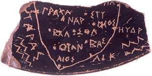
The oldest map of anywhere in the western world, dating from about 500 BC, has been unearthed in southern Italy. Known as the Soleto Map, the depiction of Apulia, the heel of Italy's "boot", is on a piece of black-glazed terracotta vase about the size of a postage stamp.
 ...
..."The map offers, to date, for the Mediterranean, and more generally for western civilisation, the oldest map of a real space," the university said recently.
Its engraved place names are indicated by points, just as on maps today, and are written in ancient Greek.
The sea on the western side, Taras (Taranto), today's Gulf of Taranto, is named in Greek. But the rest of the map is in Messapian, the ancient tongue of the local tribes, although the script is ancient Greek.
...
Apart from being the oldest geographical map from classical antiquity ever found, it is the first material proof that the ancient Greeks were drawing maps of real places before the Romans.
It was known from ancient Greek literature that the concept of a map existed and that some had been drawn but none had been found.
The ancient Chinese had a well-defined system of map-making, but modern cartography descends from techniques laid down by the ancient Greeks.
...
The Soleto map also gives vital new clues to the cultural exchange between the newly arrived Greeks and the Messapi.
They lived in the area but probably came originally from Greece as their language is believed to be a dialect of Illyrian.

No comments:
Post a Comment